Tuesday, September 20, 2016

Activity 2-4: Weeding Out a Solution

Scenario
A UAS is to be designed for precision crop-dusting. In the middle of the design process, the system is found to be overweight.
         Two subsystems – 1) Guidance, Navigation & Control [flying correctly] and 2) Payload delivery [spraying correctly] have attempted to save costs by purchasing off-the-shelf hardware, rather than a custom design, resulting in both going over their originally allotted weight budgets. Each team has suggested that the OTHER team reduce weight to compensate.
         The UAS will not be able to carry sufficient weight to spread the specified (Marketing has already talked this up to customers) amount of fertilizer over the specified area without cutting into the fuel margin. The safety engineers are uncomfortable with the idea of changing the fuel margin at all.
Write a response describing how you, as the Systems Engineer, would go about resolving this issue. Use your imagination, and try to capture what you would really do. Take into account and express in your writing the things you’ve learned so far in this module: What are your considerations? What are your priorities? What do you think about the future prospects for the “next generation, enhanced” version of the system as a result of your approach?
Solution
In regards to the scenario above, there are multiple responsibilities that I would have as the systems engineer responsible for resolving the issue between the guidance, navigation and control team and the payload delivery team. The three overarching roles that an ideal systems engineer must assume are; intermediary between design teams, the decision maker when conflicts occur between teams’ and final authority on whether a is ready to hand off to the costumer. Within each role, I must also examine and understand the requirements set forth by the customer, provide clear and concise communication between design teams, and be prepared to take charge of the project as a whole to ensure its on time, well designed, and meets expectations (Embry Riddle Aeronautical University, 2015). Below I have outlined how I would resolve to current issue by analyzing and describing how I would accomplish each one of my three overarching responsibilities.
Systems Engineer as an Intermediary
            As the systems engineer I would recognize that the two design teams that are arguing are responsible for very different systems that require very unique technical knowledge to accomplish. The skills associated with developing guidance and navigation are very technical with much of the detail in sensors and computer coding. The payload delivery design team would be more focused on the mechanical aspect of the project. The Payload design team may also feel a certain level of self-proclaimed importance due to the fact that the entire project is essentially built to perform the single task that they are reasonable for. It’s this understanding of not only the requirements and project, but it’s the interpersonal skills and understanding of the design teams as people that could help me perform my duties as an intermediary. I would work to educate both design teams as to how important the other teams contribution to the total project is and perhaps encourage them to take a minute and put themselves in the others shoes. Here we could pass ideas between the design teams and ensure both teams have a good understanding of how far they should be willing to flex in order to ensure the project completion stays the main focus. Perhaps this alone would invigorate one or both teams to seek smart and cost effective solutions to reduce weight from their respective components. 
Systems Engineer as the Decision Maker
            If acting as the intermediary failed to result in a constructive resolution to the overweight problem between both design teams, I would have to utilize the decision making responsibility of my job to seek resolution to the conflict. In general, I would have to take a very detailed look at both the requirements and the costs associated with each design teams’ components and determine for the teams how they would resolve the conflict. I would have to have enough technically knowledge of both subsystems in order to make smart and well educated decisions (System engineer vs. system architect, 2011, p. 73 sec.). Perhaps I could utilize my knowledge of the system as a whole to help both design teams work a creative solution that would lower the weight of both components. Perhaps the off the shelf systems that both teams used contained their own power control unit, but the design team associated with power control told me that they would be able to handle the power control requirements of each of the subsystems in question and both teams would be able to reduce the weight of the system through this efficiency. I would tell both teams to integrate into the main power control unit and then the conflict would be resolved. This example not only demonstrates my role as decision maker, but also reinforces my role as intermediary between design teams at the same time.
Systems Engineer as the Final Authority
            In regards to the above scenario, my role as final authority ties into all other aspects of my job as systems engineer due to the fact that my adherence to satisfying the original requirements is what sparked the conflict in the first place. If I did not take my role as the final authority seriously, I may have aloud to teams to continue forward with their current and produce a final product that was not capable of what it was advertised to do. This would hinder both current and future sales potential.
            The above responsibilities often run concurrently and continually while performing duties as a systems engineer therefore it’s essential to continually relook the requirements and current technology in order to stay one step ahead of the design process. Looking at the iterative design process, the systems engineer is in the best position to fuse future technologies into the project for the next version of the system. Perhaps in the future, a light weight navigation computer may become cheaper and therefore relieve the weight issue. On the other hand, I could reduce the allowed weight of both design teams and increase the payload capability which could make our product better than the competition. Another option would be to keep weight requirements and payload capacity the same while decreasing system cost for future iterations. A systems engineer should balance cost, performance, and capability when looking forward to future versions of systems in order to ensure relevancy in the current and future markets (Dahmann, n.d).     

References
Dahmann, J. (n.d.). A Model of Systems Engineering in a System of Systems Context. Retrieved September 19, 2016, from http://www.acq.osd.mil/se/docs/2008-04-04_CSER-Paper_Dahmann-etal-SoS.pdf  
Embry Riddle Aeronautical University. (2015). ASCI-530 unmanned systems: Module 2 - Global system design concepts, requirements and specification overview.
System engineer vs. system architect (2011). [Motion Picture]. Retrieved Sept 19, 2016, from
https://www.youtube.com/watch?v=wWnESjf4ajQ


Tuesday, September 13, 2016

The TDR-1 (1943) vs The MQ-1C (2016)

     One of the oldest UASs that utilizes a video camera and had the ability to drop ordinance is the TDR-1. In 1943 the US Navy worked with both the RCA television company and the Interstate Engineer Company to produce the TDR-1. This aircraft was made out of plywood and tubular steel and weight in at over 5,900 pounds (not including munitions). The aircraft was capable of flying over 495 NM in a single mission and could carry a 2000 pound bomb or torpedo. The radio control system and RCA television camera could be broadcasted about 8 miles to either a ground control station or a flying mothership. Considering TVs and radio controlled systems were just being invented around this time, it was an extremely cutting edge system that proved to be a capable system in combat. In 1945 the TDR-1 actually saw real combat and took out an enemy ship off the cost of the Russel Islands (Newport News Ship Building Inc., n.d.). Looking at UASs of today this system can be compared to the MQ-1C Gray Eagle due to their similarities and methodologies.

The TDR-1 Assault Drone


Similarities
            The TDR-1 and the MQ-1C both utilize video capture as a form of munition guidance and target acquisition. Both systems utilize a ground control station and portions of the electromagnetic spectrum to control both the aircraft itself and the munitions they carry. Both were fixed wing platforms and both had quite a good mission endurance range. The TDR-1 could carry over 2000 pounds of either bomb or torpedo and the MQ-1C can carry 400 pounds of precision guided munitions (GA-ASI Inc., 2016). These major broad stroke concepts are near mirror images, but upon further investigation one can see that much of the technology equipped on the MQ-1C has truly evolved dramatically since 1943. Many of the sub systems that have evolved did not only evolved for the UAS industry, but can attribute their evolution to the computer evolution, the camera evolution, and aeronautical evolution that has taken place since 1943.

The MQ-1C Gray Eagle 


Differences
            Some of the major differences has to do with the fact that integrated circuits did not exist until 1958 (TI Inc., 2008). Much of the computing was accomplished by vacuum tubes. This limited command and control to very simple techniques. Setting the altitude for the TDR-1 was done through dialing a rotary phone dial and have each number represent a particular altitude above ground level (Newport News Ship Building Inc., n.d.). As global navigation techniques evolved into GPS and INS sensors, the idea of following a UAS with a mothership or using just line of sight to figure out where it is became obsolete. The MQ-1C is equipped with redundant GPSs and INSs in order to ensure the operator knows exactly where the system is even when operating via satellites beyond line of sight (GA-ASI., 2016). Another major difference between the TDR-1 and the MQ-1C is that the MQ-1C utilizes digital communication technology. Along with an advancements in camera technology, the swap to digital communication methods allowed for much higher bandwidth communication as well as much further communication distances to include beyond line of sight.

The Future
            Looking even further into the future and taking notes from what we have seen evolved since 1943, one can see there is a bright future of UAS technology. Some of the major initiatives in the department of defense have to deal with simplification and automation of unmanned systems in general. Taking the need for highly skilled operators, and huge logistic supply chains out of the equation is one of the most vital aspects of future success of many of the current UAS programs. Much of these goals will be accomplished through standardizing future technologies, creating modular payload and interoperability with both manned and other unmanned systems (Department of Defense, 2013).   

References:

Department of Defense. (2013). Unmanned Systems Integrated Road Map FY 2013-FY2038. Retrieved September 13, 2016, from http://www.defense.gov/Portals/1/Documents/pubs/DOD-USRM-2013.pdf

GA-ASI Inc. (2016). Gray Eagle UAS. Retrieved September 13, 2016, from http://www.ga-asi.com/gray-eagle

Newport News Ship Building Inc. (n.d.). TDR-1: First Operational US Navy Drone... Successful in Combat in 1944! Retrieved September 12, 2016, from http://www.nnapprentice.com/alumni/letter/TDR_1.pdf   

TI Inc. (2008). Texas Instruments - 1958 Jack Kilby invents integrated circuit. Retrieved September 13, 2016, from http://www.ti.com/corp/docs/company/history/timeline/semicon/1950/docs/58ic_kilby.htm
    

US Army. (2016). MQ-1C Gray Eagle Unmanned Aircraft System (UAS). Retrieved September 13, 2016, from http://asc.army.mil/web/portfolio-item/aviation_gray-eagle-uas/

Friday, September 9, 2016

New Uses for UASs (Article Review)

Over the past few years, the number of applications for Unmanned Aerospace Systems (UASs) have grown significantly. Prior to 2000, UASs were reserved for NASA and the Department of Defense. Today we are starting to see small businesses, real estate agencies, and industry turn to UAS platforms to accomplish tasks that were once done by humans, airplanes, or helicopters. Due to the decline in the cost of UASs and their components, as well as the recent changes to FAA regulations that let more agencies use them legally, there has been a burst of new uses for UASs. Beyond the big stories about how Amazon is trying to set up a UAS delivery service, there are smaller and less widely known applications for UASs that will greatly affect the public in the near future.
The insurance industry is starting to use UAS in order to accomplish many subtasks associated with the industry. These subtasks include disaster claim photography and video capture, 3D mapping of auto accidents, and in the future there could even be autonomous claim capture via UAS. All of these will not only save the insurance company time and money, but the savings will be passed to the consumer as well as also expedite the claim payment. This fast claim capture could also augment emergency response efforts and speed up emergency relief funding.

In the past, a task like disaster relief is often a difficult situation to assess due to the fact that transportation into and out of the affected area is either impossible or too dangerous to do just after a disaster. In the referenced article, the man made disaster in the Port of Tianjin, China caused a 3KM exclusion zone to be formed around the port for weeks while the government determined if the explosion caused any hazardous material to become airborne. While traditional insurance companies that utilize either manned aviation assets or people on the ground waited for the exclusion zone to open up, cutting edge insurance companies utilized UASs to get real time video and photographs of the affected area. This allows the insurance companies to estimate and pay out insurance claims much faster to the companies effected by the explosion.

Image of Port of Tianjin, China After an Explosion 

Flood damage and hurricane damage are also great examples of situations where UASs could safely and quickly assess claims faster than other manned or manual methods. Because the cost of UASs are going down and the quality of cameras are going up it has created a perfect situations for companies to start utilizing UASs. Even more recently, the FAA relaxed commercial small UAS regulations which will make using UASs by insurance companies even easier.  
    
References:

Lewis, C. (2016, July 18). The future is looking up for Insurance companies and drones. Retrieved September 08, 2016, from https://robotenomics.com/2016/07/18/the-future-is-looking-up-for-insurance-companies-and-drones/  

Wednesday, August 17, 2016

Sense and Avoid Technology for UASs... Risk Mitigation vs. Complete Risk Avoidance

The integration of unmanned aerial systems (UASs) into national airspace (NAS) has been an ongoing process that is slowly but surely making small steps to a future filled with UASs. There are multiple facets that make integrating UASs into NAS a complicated process. Questions that deal with aircraft registration, operator training, ethical responsibility, hacking and lost link procedures are all on the table when it comes to integration into NAS. One topic that has been at the front and center of the integration process is sense and avoid standards and responsibilities for UASs. Companies like Amazon, Google, and Intel are all working solutions to this challenge, but the Military and government entities like NASA are also looking for solutions to getting more robust sense and avoid technology into the skies fast.

Currently in Part 91.113 of the federal aviation regulation, it lays out the rules of the sky in terms of right of way for all aircraft. One key verbiage used is that aircraft must “see and avoid”. This does not include the ability to sense and avoid, which is the method by which a UAS would accomplish this same task. Due to this, these regulations are very limiting to UAS operation. For military UAS this means that we must have visual observers that are trained and qualified observing the aircraft at all times while operating in NAS. This creates a huge logistical addition to typical training missions and is a cumbersome task to accomplish when it comes to personnel and crew management. It is reported that the FAA is attempting to alter Part 91.113 this year in order to include sense and avoid technology as a legal substitute for see and avoid (Carey, 2013).

The Army specifically has been working with a ground based sense and avoid system (GBSAA) to augment their ability to fly in NAS. I have worked with this technology during my time as a UAS commander in the Army and have seen how beneficial proper implementation could be for units stationed in the US. GBSAA works very similarly to ground based ATC radar systems, the only difference is that it is completely dedicated to a particular UAS mission. The radar picture of both participating and non-participating aircraft is collected via LSTAR ground sensors and overlaid on the ground control station’s display and moving map that is utilized by the operator to navigate the UAS (SRC Inc., 2016). When fully functional and approved by the FAA, this system would allow the Army to fly large UASs through Military Operations Airspace (MOA). For locations like Fort Campbell, Kentucky, this would greatly expand the operational area for the multiple UAS units stationed there. 

Depiction of Ground Based Sense and Avoid System by SRC Inc. 

In the civilian sector, there is a greater focus on autonomous sense and avoid capabilities. This technology will allow for smaller UASs to go further and farther than ever before. For companies like Amazon, who want to be able to deliver merchandise via UAS, it will be imperative that they can utilize autonomous drones that will legally be authorized to travel beyond line of sight as long as they are equipped with autonomous sense and avoid technology (Popper, 2016).

Regulators are attempting to find a perfect answer to the sense and avoid issue, but the technology is currently very good, but not perfect. Some argue that the technology needs to be better, while others argue that aviation has always been about risk mitigation and not risk avoidance. Companies like Intel have produced sense and avoid systems that could reduce risk nearly to zero, but not promise a perfect solution to every scenario (Popper, 2016). Many feel that the same risk acceptance levels applied to manned aviation should be carried over to unmanned aviation rather than attempting to create a more stringent and difficult standard to achieve. What do you think is the best way forward? Please feel free to respond in the comments section below.    

References:

Carey, B. (2013, July 22). FAA Plans Unmanned 'Sense and Avoid' Rule in 2016. Retrieved August 17, 2016, from http://www.ainonline.com/aviation-news/air-transport/2013-07-22/faa-plans-unmanned-sense-and-avoid-rule-2016

FAA. (2004). Part 91 GENERAL OPERATING AND FLIGHT RULE. Retrieved August 17, 2016, from http://rgl.faa.gov/Regulatory_and_Guidance_Library/rgFAR.nsf/0/934f0a02e17e7de086256eeb005192fc!OpenDocument

Popper, B. (2016, January 16). What's really standing in the way of drone delivery? Retrieved August 17, 2016, from http://www.theverge.com/2016/1/16/10777144/delivery-drones-regulations-safety-faa-autonomous-flight

SRC Inc. (2016). Ground-Based Sense and Avoid Radar System. Retrieved August 17, 2016, from http://www.srcinc.com/what-we-do/radar-and-sensors/gbsaa-radar-system.html

Thursday, August 11, 2016

UAS Strengths and Weaknesses

In the world of Military Intelligence there are many methods of intelligence collection that span well beyond typical Electro Optic Infrared (EO/IR) imagery and real time HD video. The use of hyperspectral imagery has long been a great source of information that could either stand alone or even augment other forms of imagery. Hyperspectral imagery allows people to see beyond the surface of what they are looking at by examining the specific portion of the electromagnetic spectrum that an examined material is reflecting (Richter, n.d). This data, when compared to databases, can tell the observer exactly what material they are looking at, how much moisture is in soil, and even what types of minerals are present in top soil. From a defense perspective this can help determine the difference between true vegetation and camouflage or even if some kind of metal device has been planted in the ground. From a civil perspective this imagery can help farmers determine crop viability and soil conditions in support of precision agriculture.

The military currently utilizes satellites, manned aircraft and some large UASs controlled at the national level to gather most of their hyperspectral imagery (Military & Aerospace Electronics, 2013).  This means if a particular unit wants recently collected hyperspectral imagery of an area it will need to send requests up the chain and hope that the request can be processed in a timely mater. The lag between request and collection often causes users to end up with outdated products or no products at all.

As hyperspectral sensors become cheaper, smaller, and more accessible they are starting to make their way into the hands of the public. One great example of putting the power of hyperspectral sensors into the hands of the public is in the form of the Precision Hawk. The Precision Hawk is a small UAS that is hand launched and flown completely autonomously around a preassigned area. Upon landing the system uploads to a standard laptop and processes the data almost immediately. This UAS is well inside the price range of a small scale farmer and provides high definition hyperspectral imagery to a user for a very small cost and with little training or skill (Precision Hawk In., 2016).


In order to mitigate some of the challenges that exist in obtaining military hyperspectral imagery, the military is looking into making smaller and more accessible collection platforms that can be pushed down to a more tactical level. Taking notes from small platforms like the Precision Hawk, perhaps a hand launched small UAS like the MQ-11 Raven can be equipped with advanced hyperspectral sensors. Defense sensor developers are even working on ground based hyperspectral sensors that could be put on small tactical vehicles (Military & Aerospace Electronics, 2013).    


Resources
Military & Aerospace Electronics. (2013, January 1). Hyperspectral imaging sensors come into their own for aerospace and defense applications. Retrieved August 11, 2016, from http://www.militaryaerospace.com/articles/print/volume-24/issue-1/product-intelligence/hyperspectral-imaging-sensors-come-into-their-own-for-aerospace-.html

Precision Hawk Inc. (2016). EMPOWERING THE COMMERCIAL DRONE INDUSTRY. Retrieved August 11, 2016, from http://www.precisionhawk.com/  

Richter, R. (n.d.). Hyperspectral Sensors for Military Applications. Retrieved August 11, 2016, from http://www.dtic.mil/cgi-bin/GetTRDoc?AD=ADA469649  

Wednesday, May 20, 2015

What Kind of Unmanned System Will Make the Greatest Impact on Society in the Future?

I feel that future development of unmanned aerial systems (UASs) will have the greatest impact to society compared to the future impacts of unmanned marine and ground systems. The reason why I feel this way is based on three key industries that will be greatly affected by UAS development; agriculture, transportation, and defense.  These three industries account for the most important sectors of the economy according to the US Department of commerce. Agriculture is number one for the United States, but also plays an absolutely essential role in lesser developed counties as well. Transportation is essential because it links all over services and industries to the end user, and defense is important because ultimately, when politics fail, it’s the county with the best military remains in power. Marine and ground based unmanned systems will continue to develop and shape these sectors, but opening the aerial layer to industry will provide previously unobtainable perspective, convenience, and progress.


Agriculture: There are two major aspects to agriculture that will be affected by the development of UASs; precision agriculture, and crop dusting and treatment. Precision agriculture is a farming technique that uses high tech overhead imagery to observe, measure, and respond to inter and intra field variability. In the past this could only be done via satellite or manned aircraft which resulted in costs that were too high for the average farmer to afford. Today, with the introduction of UASs, every farmer, no matter how big or small, is gaining access to this ability. The use of unmanned crop dusting and crop treatment is complimented by precision agriculture. The ability to link both precision agriculture and unmanned crop treatment means a small farmer could optimize their land to provide the highest and most cost effective crop yield scientifically possible. If applied over a large enough population, this technology could change global food yield and resources for the better.


Transportation: The transportation sector is the link between industry and the end users. The transportation sector touches almost every other sector of the global economy in some way. As globalization continues, the importance of effective and fast transposition of people and goods is becoming more important every day. The ability to fly long distance global missions can be accomplished cheaper and more efficient with large scale UASs. In terms of local and hyperlocal transportation, the use of small quadcopter may become the standard method of local delivery. Amazon has been working with the FAA to start a new program in which deliveries could be made by quadcopters within a local area. This could be a start to a future of bustling UAS highways in the air. Not only could it reduce traffic, emissions, and delivery times, but it could launch counties without proper road networks into the 21st century for minimal costs.


Defense: Currently, only a few countries rely on military UASs as heavily as the United States. It is clear that the introduction of the UAS has redefined the battlefield, but the one aspect of this technology that will effect society in the future is its availability. As UAS technology becomes cheaper and more accessible it will be spread to all international powers regardless of state affiliation, size, or political standing. In the future we could see separatist states, terrorists, or major adversaries gain access to extremely dangerous weapons and use them to disrupt peace and stability globally.  


References:

Becker, S. (2014, July 1). What Are the Most Important Sectors in the U.S. Economy? Retrieved May 20, 2015, from http://www.cheatsheet.com/business/what-are-the-most-important-sectors-in-the-u-s-economy.html/?a=viewall

Gopal, S. (2015, February 20). Drones: The Game Changers in Future Wars. Retrieved May 20, 2015, from http://www.indiandefencereview.com/news/drones-the-game-changers-in-future-wars/

Grassi, M. (2015, May 7). FAA Enters Partnerships To Consider Beyond Line-Of-Sight UAV Missions | PrecisionAg. Retrieved May 20, 2015, from http://www.precisionag.com/data/imagery/faa-enters-partnerships-to-consider-beyond-line-of-sight-uav-missions/

Jones- Cruise, C. (2015, March 18). Amazon Receives Patent for Drone Delivery System. Retrieved May 20, 2015, from http://learningenglish.voanews.com/content/amazon-receives-patent-for-drone-delivery-system/2776033.html

Friday, May 15, 2015

Implementation of an Unmanned System for Law Enforcement Surveillance

The use of unmanned aerial system by law enforcement has been a hot button topic over the past few years. The legality of 4th amendment searches, as well as the ethical questions raised when using UASs have plagued law enforcement agencies for years. In the below proposal, I will present a strategy that my help bring the T-Hawk UAS into the front line for Florida law enforcement.

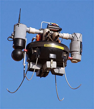
The UAS I have selected to use in my implementation strategy is the T-Hawk by Honeywell. The key to this platform is its ease of use, safety, and ability to fly in multiple weather and environmental conditions. This particular platform has been used for years by law enforcement because of its capable electro-optic/ infrared capability (EO/IR).  In order to create a successful implementation strategy, I will look at the following aspects; privacy, ethics, safety, and lost link capability.


Privacy: The T-Hawk is a gas powered vertical take off ducted fan style UAS. It is capable of flying up to 10,000 feet and at 46 miles per hour for up to 50 minutes at a time. The system has a hover and stare capability that makes it ideal for monitoring and search operations. Due to the system being gas powered, it is rather loud and noticeable (often called a flying lawnmower). The fact that this system is loud when it flies is actually a positive in terms of the debate over privacy. Due to the fact that most people within visual range of the system can hear it, means that it provides a similar aspect of privacy as a manned helicopter. For most people, the idea of the system being able to see you only when you can hear it provides a level of acceptable privacy, because they are aware of its presence. For some smaller systems that are battery powered and unable to be heard, people feel like they are being unfairly violated and unable to avoid surveillance.

Ethics: Along with privacy the idea of the ethical nature of UASs is still a hot button topic. Florida was the first state to pass the law that limits UAS use by law enforcement.  The “Freedom from Unwarranted Surveillance Act” went into effect in Florida on July 1, 2013. The root of this act ensures all UAS surveillance by law enforcement requires a warrant. The only exception is if someone’s life is at risk or an imminent threat of a terror attack exists. Currently, as long as law enforcement agencies follow this piece of legislation, there should be a minimal ethical issue. In the future, as UAS rules change, I feel that these rules should and will be changed, but as long as the law enforcement agencies operate under the current federal and state laws, then they will be successful.
   
Safety: The T-Hawk is a relatively small UAS. The key to safely employing this system would be based on a three part plan. The first two steps would include rigorous operator training and aircraft preventative maintenance. These two aspects are key to all aviation safety, and if done correctly will ensure the system is flown in the correct airspace, under the right performance constraints, and free of mechanical defects. The third part would be to only operate the system at what the FAA determines to be a safe location and altitude. In the field of UAS, operators should not strive for zero risk, but should strive to reduce unnecessary risk in all aspects of operations.

Lost Link: Due to the automated nature of the T-Hawk, lost link is less of an issue than other smaller manually controlled UASs. The system can be set with a lost link time limit that automatically issue a return home command. The system can be set to climb to a set return home altitude and then make its way back and land vertically at the initial launch point. One positive to this system is its capability of vertical flight. This will prevent the system from having to make complicated traffic patterns in order to land and will provide a very predictable lost link flight path. Additionally, to add another level of safety to lost link operations, a clearly published standard operating procedure and training will be essential to ensure the system does what is expected every time.

In conclusion, UAS hardware and software is not the key aspect to a successful implementation plan. The key is sufficient operator and maintainer training, publishing of standard procedures, and compliance with local and national laws. If a law enforcement entity spends the appropriate time and effort accomplishing those three things, the ethical and moral issues should be easy to justify and the safety and lost link concerns should be of minimal concern.

References: