Showing posts with label UAV. Show all posts

Tuesday, October 18, 2016

UAS Missions and their Respective Attributes, Challenges, and Legalities

            There are many missions that unmanned aerospace systems (UASs) accomplish in both the public and civil realms. One of the most well suited missions to UAS is aerial Intelligence, Surveillance, and Reconnaissance (ISR). This mission set it not only a military mission, it is also conducted by police, border patrol, and FBI. All agencies that conduct aerial ISR via UAS share many of the same tactics techniques and procedures to accomplish the task. The type, size, and design of the UASs used in this mission vary widely based on where the mission is being conducted, the budget that a particular agency has for the mission, as well as other mission related constraints that are unique to each agency.     
            Three examples of platforms that accomplish the role of aerial ISR are the MQ-1C Gray Eagle which is used by the US Army, the MQ-8 Fire Scout which is used by the US Navy, and the Qube which was used by the Grand Forks, ND Police department to make its first night time arrest aided by a UAS (Koebler, 2014). The MQ-1C is a standard large fuel powered fixed wing UAS designed for launch and recovery via a 5,000ft runway. The Gray Eagle is capable of flying beyond line of sight as well as loitering for over 25 hours. This long loiter time and extended range provide the US Army with a powerful and capable system for aerial ISR (GA-ASI, 2016). 
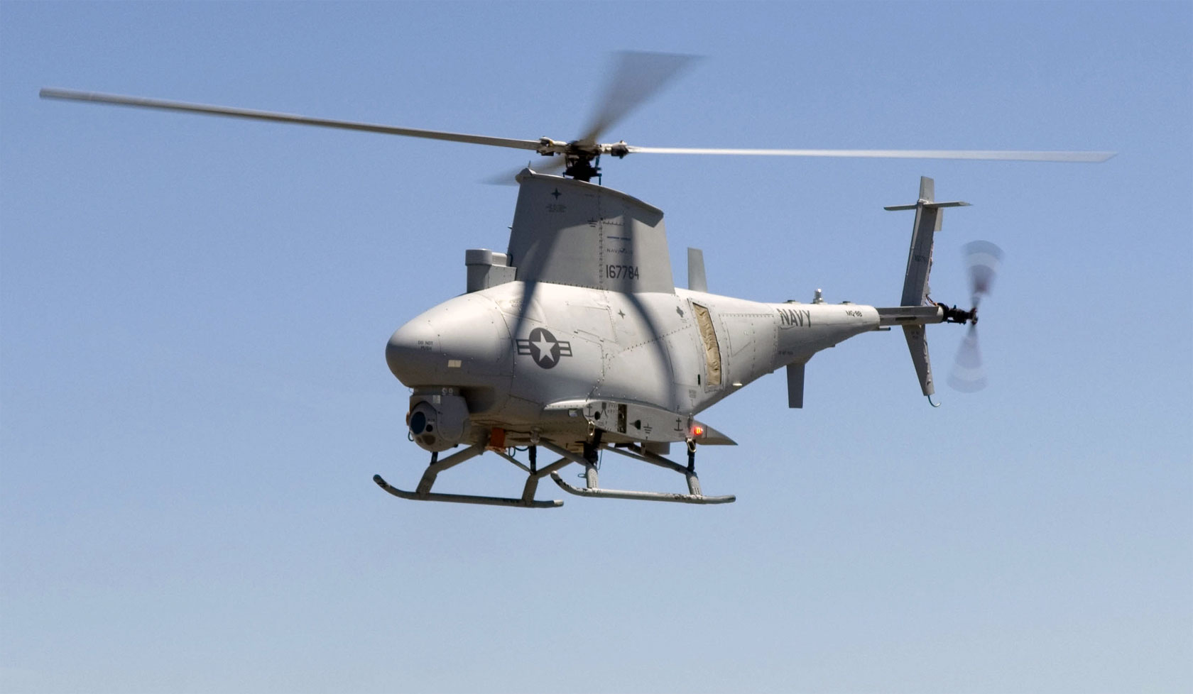
The MQ-8 Fire Scout is used by the US Navy to conduct aerial ISR, but it is a rotary wing platform which aids in launch and recovery from ships and boats. The system is capable of flight up to 16,000ft as well as can loiter for over 12 hours. While not as capable as the Gray Eagle, the Fire Scout has the huge advantage of vertical takeoff and landing, which is vital when operating at sea (Northrup Grumman Inc., 2016). 
The Qube by AeroVironoment is a small battery powered quadcopter UAS that is utilized by the Grand Forks, ND police department to aid in criminal surveillance, which is the police version of ISR. The Qube is capable of only 40 minutes of flight and has a line of sight range of only 1km, but meets both the mission requirements and budgetary constraints of a small police department (AeroVironment Inc., 2016).
            The mission requirements vary depending on where and when the mission takes place, but there are some major considerations that must be taken in to account when selecting a UAS platform. Most aerial ISR systems need to be able to gain a vantage point that humans cannot typical achieve on foot. This means that they need to be well above the target. For high value targets in Afghanistan it could mean 20,000ft loiter altitude. For a ship or marine target, 10,000ft above the ocean may be the right solution. For a police chase in an urban area, a 400ft altitude could be adequate. The other main mission task that must be executed is relaying the video photography of the target back to the operator in near real time. Regardless of size, platform type, or cost, this function is accomplished at all levels for aerial ISR UASs.
            The major challenges for conducting aerial ISR can be two fold, there are platform based challenges as well as payload based challenges. In terms of platform challenges, achieving beyond line of sight flight is expensive and technologically advanced. The use of third party satellites is expensive as well as complex. Another aspect of flying beyond line of sight domestically is that is regulatory restrictive (Anderson, 2016). One Major benefit of utilizing UASs for aerial ISR is that they can remain in the air longer than most other manned platforms. Compared to systems like the MQ-12 Liberty manned airplane that is flown by the US Air Force, most UASs regardless of size can outlast it while conducting an ISR mission. The MQ-12 can only stay aloft for 6 hours without having to break station to refuel (Airforcetechnology.com, 2016). The MQ-1C can last a full 25 hours on one tank of fuel (GA-ASI, 2016).
            There are multiple legal and moral issues that often are challenging for UAS to be utilized in aerial ISR mission, and even more so when UASs are equipped with munitions such as the hellfire missile. In the case of a military UAS conducting ISR and firing hellfires there is a moral issue as to who is to blame in case of collateral damage cause by improper target identification, or lack of target area situational awareness (McGuire, 2015). There are major legal issues when conducting ISR domestically by the police. The main issue is privacy. Privacy is a huge concern for the American public, and when conducting police action, the use of a UAS could require a warrant depending the state. California is a very conservative state when it comes to UAS use by the police. Recently the state assembly approved a law requiring police to get a warrant to use a UAS to conduct a search (Bailey, 2014). Other states are working through litigation to determine the legality of UAS surveillance by police, but there are many challenges both perceived and actual to utilizing UASs for aerial ISR both domestically and deployed.       
References
AeroVironment Inc. (2016). Visit AeroVironment Inc. Retrieved October 18, 2016, from https://www.avinc.com/uas/view/qube
Anderson, R. (2016, September 24). The opportunities and challenges of flying drones beyond line of sight (BLOS) | Commercial Drones Blog | Aviassist. Retrieved October 18, 2016, from http://www.aviassist.com.au/commercial-drones-blog/opportunities-challenges-flying-drones-beyond-line-sight-blos/
Bailey, R. (2014, August 05). California Assembly Passes Bill Requiring Police to Get a Warrant for Surveillance Drones. Retrieved October 18, 2016, from http://reason.com/blog/2014/08/05/california-assembly-passes-legislation-r
GA-ASI. (2016). Gray Eagle UAS. Retrieved October 18, 2016, from http://www.ga-asi.com/gray-eagle
Koebler, J. (2014, October 2). Police Used a Drone to Chase Down and Arrest Four DUI Suspects in a Cornfield. Retrieved October 18, 2016, from http://motherboard.vice.com/read/police-used-a-drone-to-chase-down-and-arrest-four-dui-suspects-in-a-cornfield
Maguire, L. (2015, September 26). The Ethics of Drone Warfare. Retrieved October 18, 2016, from http://www.philosophytalk.org/community/blog/laura-maguire/2015/09/ethics-drone-warfare
Northrup Grumman Inc. (2016). Fire Scout. Retrieved October 18, 2016, from http://www.northropgrumman.com/Capabilities/FireScout/Pages/default.aspx?utm_source=PrintAd


Friday, October 7, 2016

Article Review of "The Future of Drones: Uncertain, Promising and Pretty Awesome"

In the article titled The Future of Drones: Uncertain, Promising and Pretty Awesome, published in November of 2015, discusses both the exciting advancements possible in UAS technology as well as some of the difficulties facing the future of the UAS industry. The major themes that this article discusses are the current use of UASs, the future uses, and the major regulatory issues that plague future development.

When this article was written, the use of UASs to deliver packages by Amazon was the big news. Amazon was the first company to successfully deliver merchandise via UAS. Google is now working on Project Wing which is a competitor of Amazon’s Prime Air. Other universities are also working with industry to develop medical supply delivery UASs that are able to carry up to 10 lbs. worth of supplies to secluded areas. These are just some of the current technological changes occurring in 2015 and 2016.

The article goes on to discuss the FAA regulations that are changing to support the future of UAS technology. The major changes that occurred in 2016 had to do with relaxing the requirements for commercial UAS use. The author was pleasantly surprised by the permissiveness of the FAA’s new regulations that went into effect in the summer of 2016. The biggest step into the future would have to do with allowing flight beyond line of sight in order to better support autonomous deliveries that Amazon and Google are trying to accomplish.  

The next major topic that the article discussed was the huge amount of money that will be spent in the UAS market of the coming years. This year the UAS market only created about 200-400 million dollars in total revenue, but the author is predicting by 2020, UAS will create billions in revenue. The author links the future capability of being able to fly beyond line of sight as the major factor that could cause the explosion of revenue and innovation in UASs.

Finally, the author discusses the difficulties in sense and avoid technology and integration into national airspace. The biggest challenge is going to be trust between the FAA, manned aviation, and the people living around high UAS traffic areas. A proposal of a UAS traffic management (UTM) system is something that could help the integration of UAS, but there are still many hurtles both technologically and regulatory that are making the future of UASs bright, but challenging.      

Reference Article:


Gent, E. (2015, November 5). The Future of Drones: Uncertain, Promising and Pretty Awesome. Retrieved October 7, 2016, from http://www.livescience.com/52701-future-of-drones-uncertain-but-promising.html

Thursday, August 11, 2016

UAS Strengths and Weaknesses

In the world of Military Intelligence there are many methods of intelligence collection that span well beyond typical Electro Optic Infrared (EO/IR) imagery and real time HD video. The use of hyperspectral imagery has long been a great source of information that could either stand alone or even augment other forms of imagery. Hyperspectral imagery allows people to see beyond the surface of what they are looking at by examining the specific portion of the electromagnetic spectrum that an examined material is reflecting (Richter, n.d). This data, when compared to databases, can tell the observer exactly what material they are looking at, how much moisture is in soil, and even what types of minerals are present in top soil. From a defense perspective this can help determine the difference between true vegetation and camouflage or even if some kind of metal device has been planted in the ground. From a civil perspective this imagery can help farmers determine crop viability and soil conditions in support of precision agriculture.

The military currently utilizes satellites, manned aircraft and some large UASs controlled at the national level to gather most of their hyperspectral imagery (Military & Aerospace Electronics, 2013).  This means if a particular unit wants recently collected hyperspectral imagery of an area it will need to send requests up the chain and hope that the request can be processed in a timely mater. The lag between request and collection often causes users to end up with outdated products or no products at all.

As hyperspectral sensors become cheaper, smaller, and more accessible they are starting to make their way into the hands of the public. One great example of putting the power of hyperspectral sensors into the hands of the public is in the form of the Precision Hawk. The Precision Hawk is a small UAS that is hand launched and flown completely autonomously around a preassigned area. Upon landing the system uploads to a standard laptop and processes the data almost immediately. This UAS is well inside the price range of a small scale farmer and provides high definition hyperspectral imagery to a user for a very small cost and with little training or skill (Precision Hawk In., 2016).


In order to mitigate some of the challenges that exist in obtaining military hyperspectral imagery, the military is looking into making smaller and more accessible collection platforms that can be pushed down to a more tactical level. Taking notes from small platforms like the Precision Hawk, perhaps a hand launched small UAS like the MQ-11 Raven can be equipped with advanced hyperspectral sensors. Defense sensor developers are even working on ground based hyperspectral sensors that could be put on small tactical vehicles (Military & Aerospace Electronics, 2013).    


Resources
Military & Aerospace Electronics. (2013, January 1). Hyperspectral imaging sensors come into their own for aerospace and defense applications. Retrieved August 11, 2016, from http://www.militaryaerospace.com/articles/print/volume-24/issue-1/product-intelligence/hyperspectral-imaging-sensors-come-into-their-own-for-aerospace-.html

Precision Hawk Inc. (2016). EMPOWERING THE COMMERCIAL DRONE INDUSTRY. Retrieved August 11, 2016, from http://www.precisionhawk.com/  

Richter, R. (n.d.). Hyperspectral Sensors for Military Applications. Retrieved August 11, 2016, from http://www.dtic.mil/cgi-bin/GetTRDoc?AD=ADA469649  

Thursday, January 15, 2015

Article Summary of "Electro-optical sensor payloads for small UAVs"

During my pursuit of a Masters in Unmanned Systems, the topic of shrinking sensors to fit small UASs came up in a discussion during class. I decided to search the internet to see what information could be found. Below you will find a summary of an article that address the constraints and challenges of fitting Electro-Optic/ Inferred (EO/IR) sensors on small UASs.
   
The following is a summary of article titled "Electro-optical sensor payloads for small UAVs" which could be found at this LINK.


Insitu ScanEagle UAV.
This photo shows the relatively small size of the ScanEagle UAS which was studied in this article
Summary: 

Development in unmanned systems has been increasing exponentially over the past few years, and the sensors that accommodate these systems are progressing as rapidly as the systems themselves. Development is occurring in ground and marine based unmanned systems, but the requirement to shrink sensors is truly a requirement coming from the airborne sector of the unmanned world. In the world of small UAS, grams of payload directly correlate to proportionally large amounts of loiter time.

In the past, EO/IR sensors were developed for large UASs, low flying helicopters, or large manned platforms. Today, the developments in small UASs, both in the civilian and military sectors, have created a paradigm shift in the development of these EO/IR sensors. Previously, developers of EO/ IR sensors were able work "off the shelf" camera technology into operational, multi-function payloads. Today, due to the shrinking size of the air vehicles and changing mission requirements, engineers have begun to focus on building light weight solutions from ground up. This has allow requirements to truly drive development, and new EO/ IR sensors are not only lighter, but more effective for future unmanned missions. 

The author uses two examples to highlight how a paradigm shift in engineering and a fundamental change in thinking altered small UAS sensors. The first example utilizes the change from uncooled to cooled EO/IR sensors. Originally, the use of improved glass optics and uncooled IR systems cut weight and would provide adequate mission accomplishment. Today, the capability of small UASs has increased as well as the altitudes they are able to fly, and the additional weight associated with a cooled system now outweighs the limitations of the uncooled variant. The other example studies the transition from the lightweight and less precise 2 axis stabilization system to a 4 axis stabilization system. Like the cooled vs uncooled scenario, the increase in small UAS capability through UAS specific engineering requires a more stable platform which is more capable of allowing higher precision payloads to be carried.    

The article concludes by discussing how the shrinking of what were once only large UAS sensors will bring advanced functions like 3D mapping into smaller and more affordable system. Not only will the airborne systems benefit, but both ground and marine systems will benefit as well.  


Brett Chereskin